
The US state New York (NY) is the 4th largest state by population and 27th biggest state by area. New York has 62 counties ranking it the 26th state with the most counties in USA. See below some basic information about the state:
| Country: | United States |
| State: | New York |
| Abbreviation: | NY |
| Capital: | Albany |
| Largest City: | New York City |
| Population: | 19,453,561 |
| Population rank in US: | 4th |
| Total Area [mi²]: | 54,555 |
| Total Area [km²]: | 141,300 |
| Area rank in US: | 27th |
| Number of Counties: | 62 |
If you want to show data distributon per geographical area, density maps (or heat maps) are a great way to achieve this. For example, here is a New York Population Density Map per County:
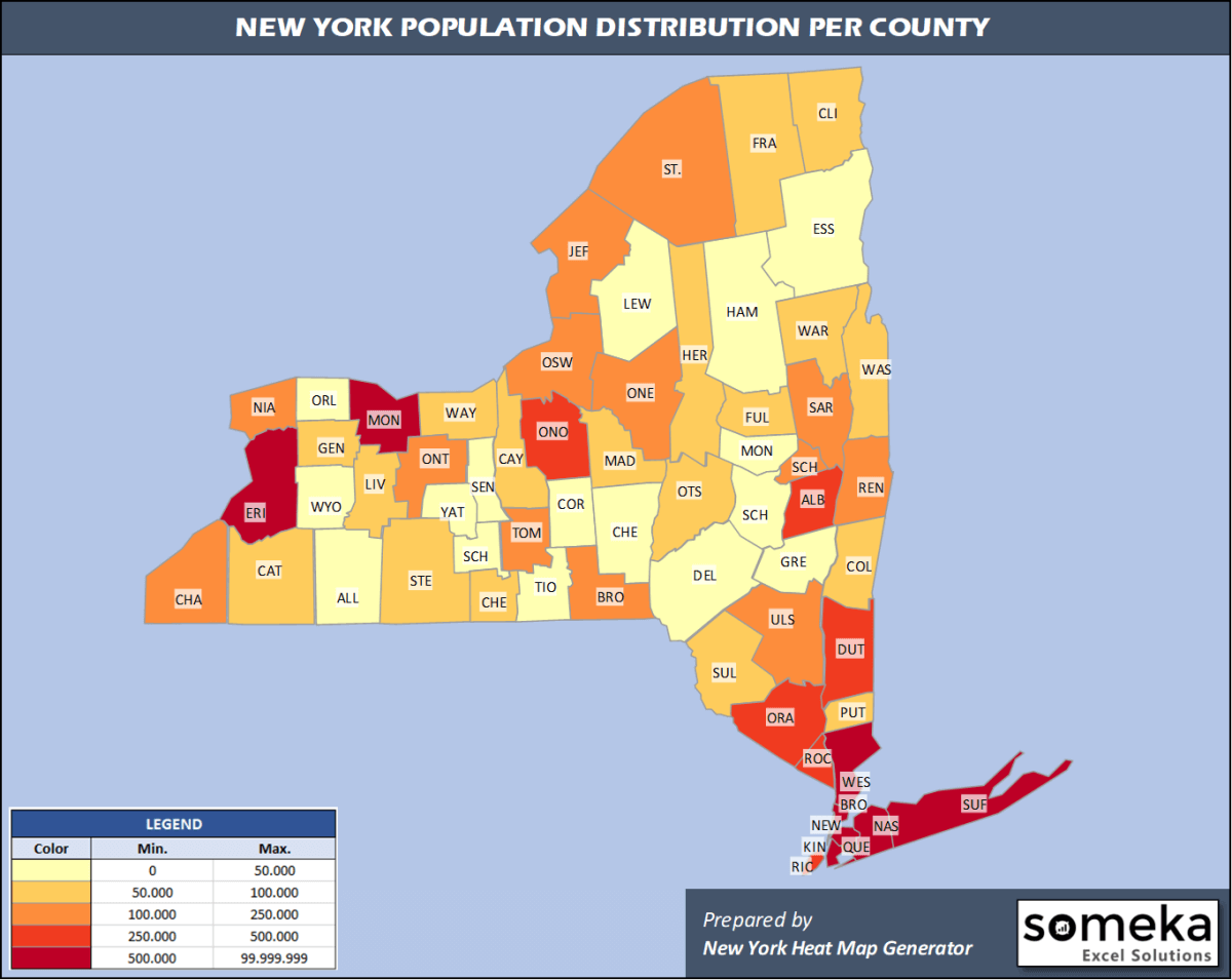
We have prepared this easily with New York County Heat Map Generator for population info. But it can also be used for many different data types such as employment rate, average temperature, racial distribution and so on.
Below are 62 New York counties ranked by population information. The data is from the US Census Bureau. You can copy and paste this list directly into your spreadsheet.
(Top 10 counties shown. To expand the list, simply click on the “show more” button)
| Rank | County | Population |
|---|---|---|
| 1 | Kings County | 2,559,903 |
| 2 | Queens County | 2,253,858 |
| 3 | New York County | 1,628,706 |
| 4 | Suffolk County | 1,476,601 |
| 5 | Bronx County | 1,418,207 |
| 6 | Nassau County | 1,356,924 |
| 7 | Westchester County | 967,506 |
| 8 | Erie County | 918,702 |
| 9 | Monroe County | 741,770 |
| 10 | Richmond County | 476,143 |
| 11 | Onondaga County | 460,528 |
| 12 | Orange County | 384,940 |
| 13 | Rockland County | 325,789 |
| 14 | Albany County | 305,506 |
| 15 | Dutchess County | 294,218 |
| 16 | Saratoga County | 229,863 |
| 17 | Oneida County | 228,671 |
| 18 | Niagara County | 209,281 |
| 19 | Broome County | 190,488 |
| 20 | Ulster County | 177,573 |
| 21 | Rensselaer County | 158,714 |
| 22 | Schenectady County | 155,299 |
| 23 | Chautauqua County | 126,903 |
| 24 | Oswego County | 117,124 |
| 25 | Jefferson County | 109,834 |
| 26 | Ontario County | 109,777 |
| 27 | St. Lawrence County | 107,740 |
| 28 | Tompkins County | 102,180 |
| 29 | Putnam County | 98,320 |
| 30 | Steuben County | 95,379 |
| 31 | Wayne County | 89,918 |
| 32 | Chemung County | 83,456 |
| 33 | Clinton County | 80,485 |
| 34 | Cayuga County | 76,576 |
| 35 | Cattaraugus County | 76,117 |
| 36 | Sullivan County | 75,432 |
| 37 | Madison County | 70,941 |
| 38 | Warren County | 63,944 |
| 39 | Livingston County | 62,914 |
| 40 | Herkimer County | 61,319 |
| 41 | Washington County | 61,204 |
| 42 | Otsego County | 59,493 |
| 43 | Columbia County | 59,461 |
| 44 | Genesee County | 57,280 |
| 45 | Fulton County | 53,383 |
| 46 | Franklin County | 50,022 |
| 47 | Montgomery County | 49,221 |
| 48 | Tioga County | 48,203 |
| 49 | Cortland County | 47,581 |
| 50 | Chenango County | 47,207 |
| 51 | Greene County | 47,188 |
| 52 | Allegany County | 46,091 |
| 53 | Delaware County | 44,135 |
| 54 | Orleans County | 40,352 |
| 55 | Wyoming County | 39,859 |
| 56 | Essex County | 36,885 |
| 57 | Seneca County | 34,016 |
| 58 | Schoharie County | 30,999 |
| 59 | Lewis County | 26,296 |
| 60 | Yates County | 24,913 |
| 61 | Schuyler County | 17,807 |
| 62 | Hamilton County | 4,416 |
Out of the 62 counties in New York, Kings County is the largest by population. St. Lawrence County is the largest by land area.
Hamilton County is the smallest New York county by population. Rockland County is the smallest by size.
In terms of economics and average income level, New York County is the richest New York county.
Bronx County is the poorest New York county.
We have prepared New York county density map by population as a downloadable PDF.
You can download the PDF for free from the link below:

New York County Density Map PDF
Check the video below to see how we use our New York County Map Excel Template to visualize any data over New York counties.
We have built the easiest New York Heat Map Maker in the universe! It works fully in Excel:
Here is a list of useful links which we think can be helpful whether you work on data visualization or make research about New York state and New York counties.
Data Source for Population and many other US related data:
https://www.census.gov
Wikipedia Page for List of New York Counties:
https://en.wikipedia.org/wiki/List_of_counties_in_New_York
Official Website of the State of New York:
https://www.ny.gov
Are you looking for New York Zip Code map?:
New York Zip Code Heat Map Generator in Excel

