
The US state Nebraska (NE) is the 37th largest state by population and 16th biggest state by area. Nebraska has 93 counties ranking it the 11th state with the most counties in USA. See below some basic information about the state:
| Country: | United States |
| State: | Nebraska |
| Abbreviation: | NE |
| Capital: | Lincoln |
| Largest City: | Omaha |
| Population: | 1,934,408 |
| Population rank in US: | 37th |
| Total Area [mi²]: | 77,358 |
| Total Area [km²]: | 200,356 |
| Area rank in US: | 16th |
| Number of Counties: | 93 |
If you want to show data distributon per geographical area, density maps (or heat maps) are a great way to achieve this. For example, here is a Nebraska Population Density Map per County:
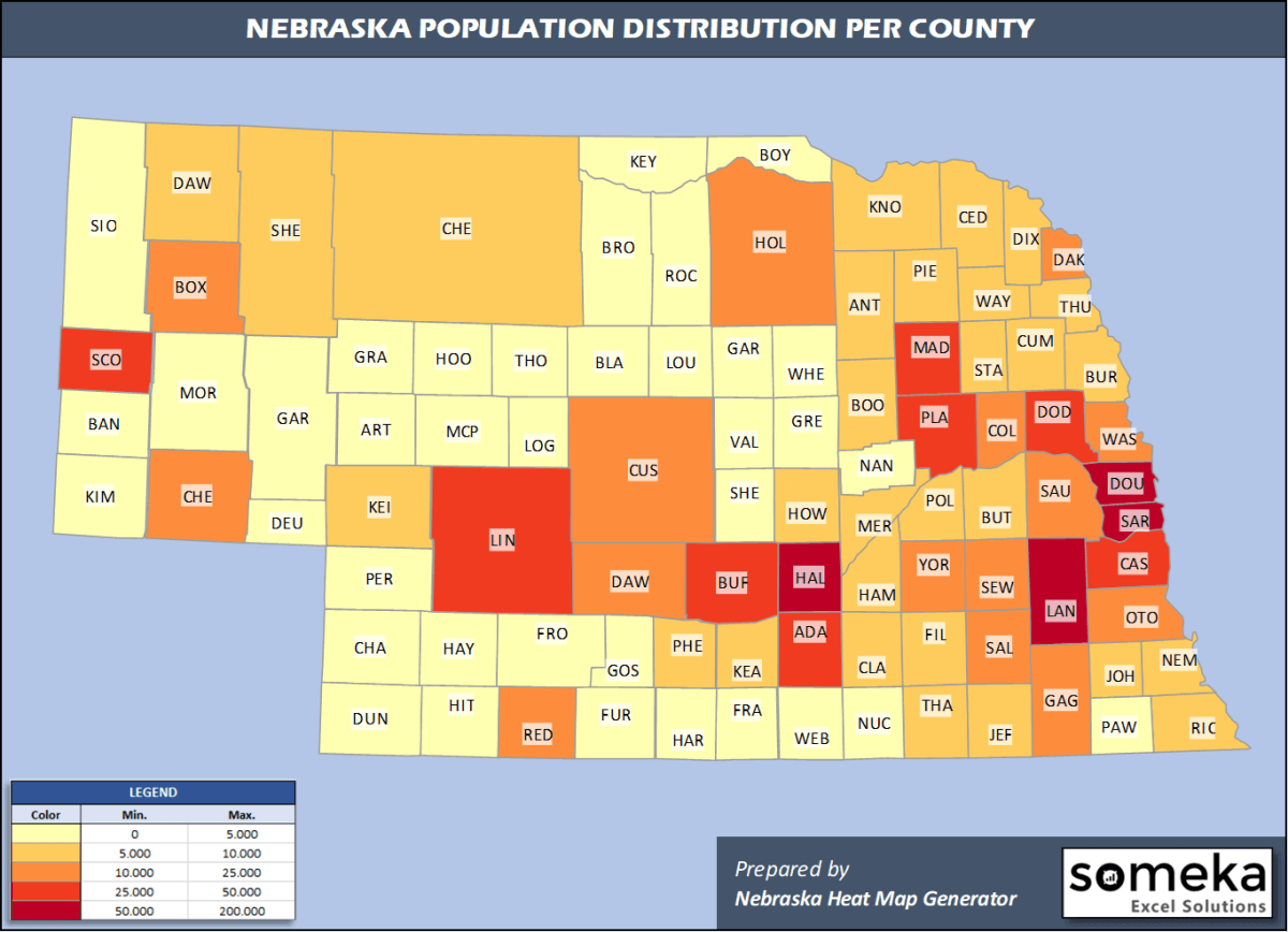
We have prepared this easily with Nebraska County Heat Map Generator for population info. But it can also be used for many different data types such as employment rate, average temperature, racial distribution and so on.
Below are 93 Nebraska counties ranked by population information. The data is from the US Census Bureau. You can copy and paste this list directly into your spreadsheet.
(Top 10 counties shown. To expand the list, simply click on the “show more” button)
| Rank | County | Population |
|---|---|---|
| 1 | Douglas County | 571,327 |
| 2 | Lancaster County | 319,090 |
| 3 | Sarpy County | 187,196 |
| 4 | Hall County | 61,353 |
| 5 | Buffalo County | 49,659 |
| 6 | Dodge County | 36,565 |
| 7 | Scotts Bluff County | 35,618 |
| 8 | Madison County | 35,099 |
| 9 | Lincoln County | 34,914 |
| 10 | Platte County | 33,470 |
| 11 | Adams County | 31,363 |
| 12 | Cass County | 26,248 |
| 13 | Dawson County | 23,595 |
| 14 | Saunders County | 21,578 |
| 15 | Gage County | 21,513 |
| 16 | Washington County | 20,729 |
| 17 | Dakota County | 20,026 |
| 18 | Seward County | 17,284 |
| 19 | Otoe County | 16,012 |
| 20 | Saline County | 14,224 |
| 21 | York County | 13,679 |
| 22 | Box Butte County | 10,783 |
| 23 | Custer County | 10,777 |
| 24 | Red Willow County | 10,724 |
| 25 | Colfax County | 10,709 |
| 26 | Holt County | 10,067 |
| 27 | Wayne County | 9,385 |
| 28 | Hamilton County | 9,324 |
| 29 | Phelps County | 9,034 |
| 30 | Cheyenne County | 8,910 |
| 31 | Cuming County | 8,846 |
| 32 | Dawes County | 8,589 |
| 33 | Cedar County | 8,402 |
| 34 | Knox County | 8,332 |
| 35 | Keith County | 8,034 |
| 36 | Butler County | 8,016 |
| 37 | Richardson County | 7,865 |
| 38 | Merrick County | 7,755 |
| 39 | Thurston County | 7,224 |
| 40 | Pierce County | 7,148 |
| 41 | Jefferson County | 7,046 |
| 42 | Nemaha County | 6,972 |
| 43 | Kearney County | 6,495 |
| 44 | Burt County | 6,459 |
| 45 | Howard County | 6,445 |
| 46 | Antelope County | 6,298 |
| 47 | Clay County | 6,203 |
| 48 | Stanton County | 5,920 |
| 49 | Cherry County | 5,689 |
| 50 | Dixon County | 5,636 |
| 51 | Fillmore County | 5,462 |
| 52 | Sheridan County | 5,246 |
| 53 | Polk County | 5,213 |
| 54 | Boone County | 5,192 |
| 55 | Johnson County | 5,071 |
| 56 | Thayer County | 5,003 |
| 57 | Furnas County | 4,676 |
| 58 | Morrill County | 4,642 |
| 59 | Valley County | 4,158 |
| 60 | Nuckolls County | 4,148 |
| 61 | Chase County | 3,924 |
| 62 | Kimball County | 3,632 |
| 63 | Nance County | 3,519 |
| 64 | Webster County | 3,487 |
| 65 | Harlan County | 3,380 |
| 66 | Sherman County | 3,001 |
| 67 | Franklin County | 2,979 |
| 68 | Brown County | 2,955 |
| 69 | Perkins County | 2,891 |
| 70 | Hitchcock County | 2,762 |
| 71 | Frontier County | 2,627 |
| 72 | Pawnee County | 2,613 |
| 73 | Greeley County | 2,356 |
| 74 | Gosper County | 1,990 |
| 75 | Garfield County | 1,969 |
| 76 | Boyd County | 1,919 |
| 77 | Garden County | 1,837 |
| 78 | Deuel County | 1,794 |
| 79 | Dundy County | 1,693 |
| 80 | Rock County | 1,357 |
| 81 | Sioux County | 1,166 |
| 82 | Hayes County | 922 |
| 83 | Keya Paha County | 806 |
| 84 | Wheeler County | 783 |
| 85 | Logan County | 748 |
| 86 | Banner County | 745 |
| 87 | Thomas County | 722 |
| 88 | Hooker County | 682 |
| 89 | Loup County | 664 |
| 90 | Grant County | 623 |
| 91 | McPherson County | 494 |
| 92 | Blaine County | 465 |
| 93 | Arthur County | 463 |
Out of the 93 counties in Nebraska, Douglas County is the largest by population. Cherry County is the largest by land area.
Arthur County is the smallest Nebraska county by population. Sarpy County is the smallest by size.
In terms of economics and average income level, Thomas County is the richest Nebraska county.
Loup County is the poorest Nebraska county.
We have prepared Nebraska county density map by population as a downloadable PDF.
You can download the PDF for free from the link below:

Nebraska County Density Map PDF
Check the video below to see how we use our Nebraska County Map Excel Template to visualize any data over Nebraska counties.
We have built the easiest Nebraska Heat Map Maker in the universe! It works fully in Excel:
Here is a list of useful links which we think can be helpful whether you work on data visualization or make research about Nebraska state and Nebraska counties.
Data Source for Population and many other US related data:
https://www.census.gov
Wikipedia Page for List of Nebraska Counties:
https://en.wikipedia.org/wiki/List_of_counties_in_Nebraska
Official Website of the State of Nebraska:
https://www.nebraska.gov
Are you looking for Nebraska Zip Code map?:
Nebraska Zip Code Heat Map Generator in Excel

