
The US state Minnesota (MN) is the 22nd largest state by population and 12th biggest state by area. Minnesota has 87 counties ranking it the 14th state with the most counties in USA. See below some basic information about the state:
| Country: | United States |
| State: | Minnesota |
| Abbreviation: | MN |
| Capital: | Saint Paul |
| Largest City: | Minneapolis |
| Population: | 5,639,632 |
| Population rank in US: | 22nd |
| Total Area [mi²]: | 86,950 |
| Total Area [km²]: | 225,163 |
| Area rank in US: | 12th |
| Number of Counties: | 87 |
If you want to show data distributon per geographical area, density maps (or heat maps) are a great way to achieve this. For example, here is a Minnesota Population Density Map per County:
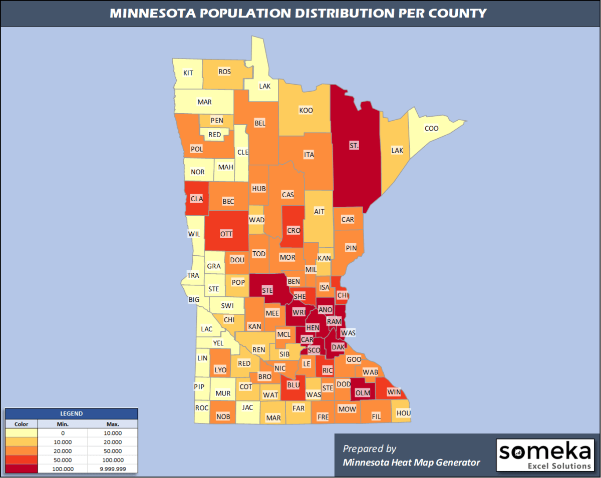
We have prepared this easily with Minnesota County Heat Map Generator for population info. But it can also be used for many different data types such as employment rate, average temperature, racial distribution and so on.
Below are 87 Minnesota counties ranked by population information. The data is from the US Census Bureau. You can copy and paste this list directly into your spreadsheet.
(Top 10 counties shown. To expand the list, simply click on the “show more” button)
| Rank | County | Population |
|---|---|---|
| 1 | Hennepin County | 1,265,843 |
| 2 | Ramsey County | 550,321 |
| 3 | Dakota County | 429,021 |
| 4 | Anoka County | 356,921 |
| 5 | Washington County | 262,440 |
| 6 | St. Louis County | 199,070 |
| 7 | Stearns County | 161,075 |
| 8 | Olmsted County | 158,293 |
| 9 | Scott County | 149,013 |
| 10 | Wright County | 138,377 |
| 11 | Carver County | 105,089 |
| 12 | Sherburne County | 97,238 |
| 13 | Blue Earth County | 67,653 |
| 14 | Rice County | 66,972 |
| 15 | Crow Wing County | 65,055 |
| 16 | Clay County | 64,222 |
| 17 | Otter Tail County | 58,746 |
| 18 | Chisago County | 56,579 |
| 19 | Winona County | 50,484 |
| 20 | Beltrami County | 47,188 |
| 21 | Goodhue County | 46,340 |
| 22 | Itasca County | 45,130 |
| 23 | Kandiyohi County | 43,199 |
| 24 | Benton County | 40,889 |
| 25 | Isanti County | 40,596 |
| 26 | Mower County | 40,062 |
| 27 | Douglas County | 38,141 |
| 28 | Steele County | 36,649 |
| 29 | McLeod County | 35,893 |
| 30 | Carlton County | 35,871 |
| 31 | Becker County | 34,423 |
| 32 | Nicollet County | 34,274 |
| 33 | Morrison County | 33,386 |
| 34 | Polk County | 31,364 |
| 35 | Freeborn County | 30,281 |
| 36 | Cass County | 29,779 |
| 37 | Pine County | 29,579 |
| 38 | Le Sueur County | 28,887 |
| 39 | Mille Lacs County | 26,277 |
| 40 | Lyon County | 25,474 |
| 41 | Brown County | 25,008 |
| 42 | Todd County | 24,664 |
| 43 | Meeker County | 23,222 |
| 44 | Nobles County | 21,629 |
| 45 | Wabasha County | 21,627 |
| 46 | Hubbard County | 21,491 |
| 47 | Fillmore County | 21,067 |
| 48 | Dodge County | 20,934 |
| 49 | Martin County | 19,683 |
| 50 | Waseca County | 18,612 |
| 51 | Houston County | 18,600 |
| 52 | Kanabec County | 16,337 |
| 53 | Aitkin County | 15,886 |
| 54 | Redwood County | 15,170 |
| 55 | Roseau County | 15,165 |
| 56 | Sibley County | 14,865 |
| 57 | Renville County | 14,548 |
| 58 | Pennington County | 14,119 |
| 59 | Wadena County | 13,682 |
| 60 | Faribault County | 13,653 |
| 61 | Koochiching County | 12,229 |
| 62 | Chippewa County | 11,800 |
| 63 | Pope County | 11,249 |
| 64 | Cottonwood County | 11,196 |
| 65 | Watonwan County | 10,897 |
| 66 | Lake County | 10,641 |
| 67 | Jackson County | 9,846 |
| 68 | Stevens County | 9,805 |
| 69 | Yellow Medicine County | 9,709 |
| 70 | Marshall County | 9,336 |
| 71 | Rock County | 9,315 |
| 72 | Swift County | 9,266 |
| 73 | Pipestone County | 9,126 |
| 74 | Clearwater County | 8,818 |
| 75 | Murray County | 8,194 |
| 76 | Lac qui Parle County | 6,623 |
| 77 | Norman County | 6,375 |
| 78 | Wilkin County | 6,207 |
| 79 | Grant County | 5,972 |
| 80 | Lincoln County | 5,639 |
| 81 | Mahnomen County | 5,527 |
| 82 | Cook County | 5,463 |
| 83 | Big Stone County | 4,991 |
| 84 | Kittson County | 4,298 |
| 85 | Red Lake County | 4,055 |
| 86 | Lake of the Woods County | 3,740 |
| 87 | Traverse County | 3,259 |
Out of the 87 counties in Minnesota, Hennepin County is the largest by population. St. Louis County is the largest by land area.
Traverse County is the smallest Minnesota county by population. Ramsey County is the smallest by size.
In terms of economics and average income level, Scott County is the richest Minnesota county.
Mahnomen County is the poorest Minnesota county.
We have prepared Minnesota county density map by population as a downloadable PDF.
You can download the PDF for free from the link below:

Minnesota County Density Map PDF
Check the video below to see how we use our Minnesota County Map Excel Template to visualize any data over Minnesota counties.

We have built the easiest Minnesota Heat Map Maker in the universe! It works fully in Excel:
Here is a list of useful links which we think can be helpful whether you work on data visualization or make research about Minnesota state and Minnesota counties.
Data Source for Population and many other US related data:
https://www.census.gov
Wikipedia Page for List of Minnesota Counties:
https://en.wikipedia.org/wiki/List_of_counties_in_Minnesota
Official Website of the State of Minnesota:
https://www.mn.gov
Are you looking for Minnesota Zip Code map?:
Minnesota Zip Code Heat Map Generator in Excel

