
The US state Indiana (IN) is the 17th largest state by population and 38th biggest state by area. Indiana has 92 counties ranking it the 12th state with the most counties in USA. See below some basic information about the state:
| Country: | United States |
| State: | Indiana |
| Abbreviation: | IN |
| Capital: | Indianapolis |
| Largest City: | Indianapolis |
| Population: | 6,732,219 |
| Population rank in US: | 17th |
| Total Area [mi²]: | 36,418 |
| Total Area [km²]: | 94,321 |
| Area rank in US: | 38th |
| Number of Counties: | 92 |
If you want to show data distributon per geographical area, density maps (or heat maps) are a great way to achieve this. For example, here is a Indiana Population Density Map per County:
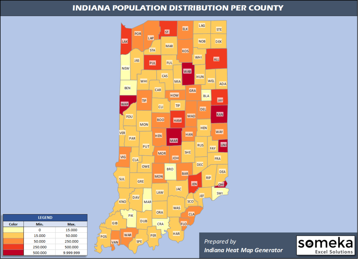
We have prepared this easily with Indiana County Heat Map Generator for population info. But it can also be used for many different data types such as employment rate, average temperature, racial distribution and so on.
Below are 92 Indiana counties ranked by population information. The data is from the US Census Bureau. You can copy and paste this list directly into your spreadsheet.
(Top 10 counties shown. To expand the list, simply click on the “show more” button)
| Rank | County | Population |
|---|---|---|
| 1 | Marion County | 964,582 |
| 2 | Lake County | 485,493 |
| 3 | Allen County | 379,299 |
| 4 | Hamilton County | 338,011 |
| 5 | St. Joseph County | 271,826 |
| 6 | Elkhart County | 206,341 |
| 7 | Tippecanoe County | 195,732 |
| 8 | Vanderburgh County | 181,451 |
| 9 | Porter County | 170,389 |
| 10 | Hendricks County | 170,311 |
| 11 | Johnson County | 158,167 |
| 12 | Monroe County | 148,431 |
| 13 | Madison County | 129,569 |
| 14 | Clark County | 118,302 |
| 15 | Delaware County | 114,135 |
| 16 | LaPorte County | 109,888 |
| 17 | Vigo County | 107,038 |
| 18 | Bartholomew County | 83,779 |
| 19 | Howard County | 82,544 |
| 20 | Kosciusko County | 79,456 |
| 21 | Floyd County | 78,522 |
| 22 | Hancock County | 78,168 |
| 23 | Morgan County | 70,489 |
| 24 | Boone County | 67,843 |
| 25 | Wayne County | 65,884 |
| 26 | Grant County | 65,769 |
| 27 | Warrick County | 62,998 |
| 28 | Dearborn County | 49,458 |
| 29 | Henry County | 47,972 |
| 30 | Noble County | 47,744 |
| 31 | Marshall County | 46,258 |
| 32 | Lawrence County | 45,370 |
| 33 | Shelby County | 44,729 |
| 34 | Jackson County | 44,231 |
| 35 | DeKalb County | 43,475 |
| 36 | Dubois County | 42,736 |
| 37 | Harrison County | 40,515 |
| 38 | LaGrange County | 39,614 |
| 39 | Montgomery County | 38,338 |
| 40 | Cass County | 37,689 |
| 41 | Putnam County | 37,576 |
| 42 | Knox County | 36,594 |
| 43 | Huntington County | 36,520 |
| 44 | Adams County | 35,777 |
| 45 | Miami County | 35,516 |
| 46 | Steuben County | 34,594 |
| 47 | Whitley County | 33,964 |
| 48 | Gibson County | 33,659 |
| 49 | Jasper County | 33,562 |
| 50 | Daviess County | 33,351 |
| 51 | Clinton County | 32,399 |
| 52 | Jefferson County | 32,308 |
| 53 | Greene County | 31,922 |
| 54 | Wabash County | 30,996 |
| 55 | Ripley County | 28,324 |
| 56 | Wells County | 28,296 |
| 57 | Washington County | 28,036 |
| 58 | Jennings County | 27,735 |
| 59 | Decatur County | 26,559 |
| 60 | Clay County | 26,225 |
| 61 | Posey County | 25,427 |
| 62 | Randolph County | 24,665 |
| 63 | White County | 24,102 |
| 64 | Scott County | 23,873 |
| 65 | Fayette County | 23,102 |
| 66 | Starke County | 22,995 |
| 67 | Franklin County | 22,758 |
| 68 | Owen County | 20,799 |
| 69 | Sullivan County | 20,669 |
| 70 | Jay County | 20,436 |
| 71 | Spencer County | 20,277 |
| 72 | Carroll County | 20,257 |
| 73 | Fulton County | 19,974 |
| 74 | Orange County | 19,646 |
| 75 | Perry County | 19,169 |
| 76 | Parke County | 16,937 |
| 77 | Rush County | 16,581 |
| 78 | Fountain County | 16,346 |
| 79 | Vermillion County | 15,498 |
| 80 | Tipton County | 15,148 |
| 81 | Brown County | 15,092 |
| 82 | Newton County | 13,984 |
| 83 | Pike County | 12,389 |
| 84 | Pulaski County | 12,353 |
| 85 | Blackford County | 11,758 |
| 86 | Switzerland County | 10,751 |
| 87 | Crawford County | 10,577 |
| 88 | Martin County | 10,255 |
| 89 | Benton County | 8,748 |
| 90 | Warren County | 8,265 |
| 91 | Union County | 7,054 |
| 92 | Ohio County | 5,875 |
Out of the 92 counties in Indiana, Marion County is the largest by population. Allen County is the largest by land area.
Ohio County is the smallest Indiana county by population. Ohio County is the smallest by size.
In terms of economics and average income level, Boone County is the richest Indiana county.
Hamilton County is the poorest Indiana county.
We have prepared Indiana county density map by population as a downloadable PDF.
You can download the PDF for free from the link below:

Indiana County Density Map PDF
Check the video below to see how we use our Indiana County Map Excel Template to visualize any data over Indiana counties.
We have built the easiest Indiana Heat Map Maker in the universe! It works fully in Excel:
Here is a list of useful links which we think can be helpful whether you work on data visualization or make research about Indiana state and Indiana counties.
Data Source for Population and many other US related data:
https://www.census.gov
Wikipedia Page for List of Indiana Counties:
https://en.wikipedia.org/wiki/List_of_counties_in_Indiana
Official Website of the State of Indiana:
https://www.in.gov
Are you looking for Indiana Zip Code map?:
Indiana Zip Code Heat Map Generator in Excel

