
The US state Virginia (VA) is the 12th largest state by population and 35th biggest state by area. Virginia has 133 counties ranking it the 3rd state with the most counties in USA. See below some basic information about the state:
| Country: | United States |
| State: | Virginia |
| Abbreviation: | VA |
| Capital: | Richmond |
| Largest City: | Virginia Beach |
| Population: | 8,535,519 |
| Population rank in US: | 12th |
| Total Area [mi²]: | 42,774 |
| Total Area [km²]: | 110,785 |
| Area rank in US: | 35th |
| Number of Counties: | 133 |
If you want to show data distributon per geographical area, density maps (or heat maps) are a great way to achieve this. For example, here is a Virginia Population Density Map per County:
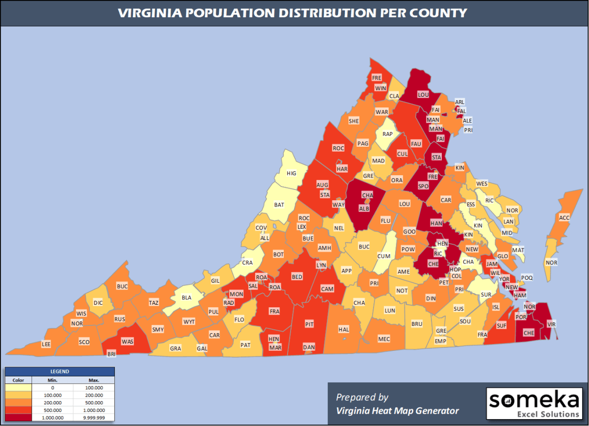
We have prepared this easily with Virginia County Heat Map Generator for population info. But it can also be used for many different data types such as employment rate, average temperature, racial distribution and so on.
Below are 133 Virginia counties ranked by population information. The data is from the US Census Bureau. You can copy and paste this list directly into your spreadsheet.
(Top 10 counties shown. To expand the list, simply click on the “show more” button)
| Rank | County | Population |
|---|---|---|
| 1 | Fairfax County | 1,147,532 |
| 2 | Prince William County | 470,335 |
| 3 | Virginia Beach city/county | 449,974 |
| 4 | Loudoun County | 413,538 |
| 5 | Chesterfield County | 352,802 |
| 6 | Henrico County | 330,818 |
| 7 | Chesapeake city/county | 244,835 |
| 8 | Norfolk city/county | 242,742 |
| 9 | Arlington County | 236,842 |
| 10 | Richmond city/county | 230,436 |
| 11 | Newport News city/county | 179,225 |
| 12 | Alexandria city/county | 159,428 |
| 13 | Stafford County | 152,882 |
| 14 | Spotsylvania County | 136,215 |
| 15 | Hampton city/county | 134,510 |
| 16 | Albemarle County | 109,330 |
| 17 | Hanover County | 107,766 |
| 18 | Roanoke city/county | 99,143 |
| 19 | Montgomery County | 98,535 |
| 20 | Portsmouth city/county | 94,398 |
| 21 | Roanoke County | 94,186 |
| 22 | Suffolk city/county | 92,108 |
| 23 | Frederick County | 89,313 |
| 24 | Lynchburg city/county | 82,168 |
| 25 | Rockingham County | 81,948 |
| 26 | Bedford County | 78,997 |
| 27 | James City County | 76,523 |
| 28 | Augusta County | 75,558 |
| 29 | Fauquier County | 71,222 |
| 30 | York County | 68,280 |
| 31 | Pittsylvania County | 60,354 |
| 32 | Franklin County | 56,042 |
| 33 | Campbell County | 54,885 |
| 34 | Washington County | 53,740 |
| 35 | Harrisonburg city/county | 53,016 |
| 36 | Culpeper County | 52,605 |
| 37 | Henry County | 50,557 |
| 38 | Charlottesville city/county | 47,266 |
| 39 | Shenandoah County | 43,616 |
| 40 | Manassas city/county | 41,085 |
| 41 | Tazewell County | 40,595 |
| 42 | Warren County | 40,164 |
| 43 | Danville city/county | 40,044 |
| 44 | Prince George County | 38,353 |
| 45 | Louisa County | 37,591 |
| 46 | Wise County | 37,383 |
| 47 | Gloucester County | 37,348 |
| 48 | Isle of Wight County | 37,109 |
| 49 | Orange County | 37,051 |
| 50 | Pulaski County | 34,027 |
| 51 | Halifax County | 33,911 |
| 52 | Botetourt County | 33,419 |
| 53 | Accomack County | 32,316 |
| 54 | Amherst County | 31,605 |
| 55 | Petersburg city/county | 31,346 |
| 56 | Caroline County | 30,725 |
| 57 | Mecklenburg County | 30,587 |
| 58 | Smyth County | 30,104 |
| 59 | Carroll County | 29,791 |
| 60 | Powhatan County | 29,652 |
| 61 | Fredericksburg city/county | 29,036 |
| 62 | Wythe County | 28,684 |
| 63 | Dinwiddie County | 28,544 |
| 64 | Winchester city/county | 28,078 |
| 65 | Fluvanna County | 27,270 |
| 66 | King George County | 26,836 |
| 67 | Russell County | 26,586 |
| 68 | Salem city/county | 25,301 |
| 69 | Staunton city/county | 24,932 |
| 70 | Fairfax city/county | 24,019 |
| 71 | Page County | 23,902 |
| 72 | Goochland County | 23,753 |
| 73 | Lee County | 23,423 |
| 74 | New Kent County | 23,091 |
| 75 | Prince Edward County | 22,802 |
| 76 | Waynesboro city/county | 22,630 |
| 77 | Rockbridge County | 22,573 |
| 78 | Hopewell city/county | 22,529 |
| 79 | Scott County | 21,566 |
| 80 | Buchanan County | 21,004 |
| 81 | Greene County | 19,819 |
| 82 | Radford city/county | 18,249 |
| 83 | Westmoreland County | 18,015 |
| 84 | Southampton County | 17,631 |
| 85 | Patrick County | 17,608 |
| 86 | Manassas Park city/county | 17,478 |
| 87 | Colonial Heights city/county | 17,370 |
| 88 | King William County | 17,148 |
| 89 | Buckingham County | 17,148 |
| 90 | Bristol city/county | 16,762 |
| 91 | Giles County | 16,720 |
| 92 | Brunswick County | 16,231 |
| 93 | Appomattox County | 15,911 |
| 94 | Floyd County | 15,749 |
| 95 | Grayson County | 15,550 |
| 96 | Nottoway County | 15,232 |
| 97 | Williamsburg city/county | 14,954 |
| 98 | Nelson County | 14,930 |
| 99 | Alleghany County | 14,860 |
| 100 | Clarke County | 14,619 |
| 101 | Falls Church city/county | 14,617 |
| 102 | Dickenson County | 14,318 |
| 103 | Madison County | 13,261 |
| 104 | Amelia County | 13,145 |
| 105 | Martinsville city/county | 12,554 |
| 106 | Poquoson city/county | 12,271 |
| 107 | Lunenburg County | 12,196 |
| 108 | Northumberland County | 12,095 |
| 109 | Charlotte County | 11,880 |
| 110 | Northampton County | 11,710 |
| 111 | Greensville County | 11,336 |
| 112 | Sussex County | 11,159 |
| 113 | Essex County | 10,953 |
| 114 | Lancaster County | 10,603 |
| 115 | Middlesex County | 10,582 |
| 116 | Cumberland County | 9,932 |
| 117 | Richmond County | 9,023 |
| 118 | Mathews County | 8,834 |
| 119 | Franklin city/county | 7,967 |
| 120 | Lexington city/county | 7,446 |
| 121 | Rappahannock County | 7,370 |
| 122 | King and Queen County | 7,025 |
| 123 | Charles City County | 6,963 |
| 124 | Buena Vista city/county | 6,478 |
| 125 | Surry County | 6,422 |
| 126 | Galax city/county | 6,347 |
| 127 | Bland County | 6,280 |
| 128 | Covington city/county | 5,538 |
| 129 | Emporia city/county | 5,346 |
| 130 | Craig County | 5,131 |
| 131 | Bath County | 4,147 |
| 132 | Norton city/county | 3,981 |
| 133 | Highland County | 2,190 |
Out of the 133 counties in Virginia, Fairfax County is the largest by population. Pittsylvania County is the largest by land area.
Highland County is the smallest Virginia county by population. Arlington County is the smallest by size.
In terms of economics and average income level, Arlington County is the richest Virginia county.
Buchanan Essex County is the poorest Virginia county.
We have prepared Virginia county density map by population as a downloadable PDF.
You can download the PDF for free from the link below:

Virginia County Density Map PDF
Check the video below to see how we use our Virginia County Map Excel Template to visualize any data over Virginia counties.
We have built the easiest Virginia Heat Map Maker in the universe! It works fully in Excel:
Here is a list of useful links which we think can be helpful whether you work on data visualization or make research about Virginia state and Virginia counties.
Data Source for Population and many other US related data:
https://www.census.gov
Wikipedia Page for List of Virginia Counties:
https://en.wikipedia.org/wiki/List_of_cities_and_counties_in_Virginia
Official Website of the State of Virginia:
https://www.virginia.gov
Are you looking for Virginia Zip Code map?:
Virginia Zip Code Heat Map Generator in Excel

