
The US state Ohio (OH) is the 7th largest state by population and 34th biggest state by area. Ohio has 88 counties ranking it the 13th state with the most counties in USA. See below some basic information about the state:
| Country: | United States |
| State: | Ohio |
| Abbreviation: | OH |
| Capital: | Columbus |
| Largest City: | Columbus |
| Population: | 11,689,100 |
| Population rank in US: | 7th |
| Total Area [mi²]: | 44,825 |
| Total Area [km²]: | 116,096 |
| Area rank in US: | 34th |
| Number of Counties: | 88 |
If you want to show data distributon per geographical area, density maps (or heat maps) are a great way to achieve this. For example, here is a Ohio Population Density Map per County:
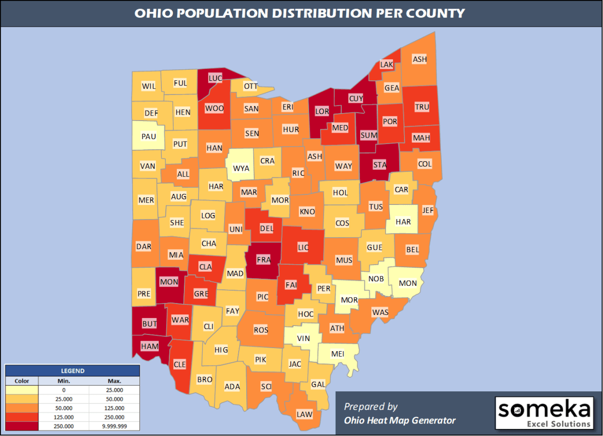
We have prepared this easily with Ohio County Heat Map Generator for population info. But it can also be used for many different data types such as employment rate, average temperature, racial distribution and so on.
Below are 88 Ohio counties ranked by population information. The data is from the US Census Bureau. You can copy and paste this list directly into your spreadsheet.
(Top 10 counties shown. To expand the list, simply click on the “show more” button)
| Rank | County | Population |
|---|---|---|
| 1 | Franklin County | 1,316,756 |
| 2 | Cuyahoga County | 1,235,072 |
| 3 | Hamilton County | 817,473 |
| 4 | Summit County | 541,013 |
| 5 | Montgomery County | 531,687 |
| 6 | Lucas County | 428,348 |
| 7 | Butler County | 383,134 |
| 8 | Stark County | 370,606 |
| 9 | Lorain County | 309,833 |
| 10 | Warren County | 234,602 |
| 11 | Lake County | 230,149 |
| 12 | Mahoning County | 228,683 |
| 13 | Delaware County | 209,177 |
| 14 | Clermont County | 206,428 |
| 15 | Trumbull County | 197,974 |
| 16 | Medina County | 179,746 |
| 17 | Licking County | 176,862 |
| 18 | Greene County | 168,937 |
| 19 | Portage County | 162,466 |
| 20 | Fairfield County | 157,574 |
| 21 | Clark County | 134,083 |
| 22 | Wood County | 130,817 |
| 23 | Richland County | 121,154 |
| 24 | Wayne County | 115,710 |
| 25 | Miami County | 106,987 |
| 26 | Allen County | 102,351 |
| 27 | Columbiana County | 101,883 |
| 28 | Ashtabula County | 97,241 |
| 29 | Geauga County | 93,649 |
| 30 | Tuscarawas County | 91,987 |
| 31 | Muskingum County | 86,215 |
| 32 | Ross County | 76,666 |
| 33 | Hancock County | 75,783 |
| 34 | Scioto County | 75,314 |
| 35 | Erie County | 74,266 |
| 36 | Belmont County | 67,006 |
| 37 | Athens County | 65,327 |
| 38 | Jefferson County | 65,325 |
| 39 | Marion County | 65,093 |
| 40 | Knox County | 62,322 |
| 41 | Washington County | 59,911 |
| 42 | Lawrence County | 59,463 |
| 43 | Union County | 58,988 |
| 44 | Sandusky County | 58,518 |
| 45 | Pickaway County | 58,457 |
| 46 | Huron County | 58,266 |
| 47 | Seneca County | 55,178 |
| 48 | Ashland County | 53,484 |
| 49 | Darke County | 51,113 |
| 50 | Shelby County | 48,590 |
| 51 | Logan County | 45,672 |
| 52 | Auglaize County | 45,656 |
| 53 | Madison County | 44,731 |
| 54 | Holmes County | 43,960 |
| 55 | Brown County | 43,432 |
| 56 | Highland County | 43,161 |
| 57 | Fulton County | 42,126 |
| 58 | Clinton County | 41,968 |
| 59 | Crawford County | 41,494 |
| 60 | Mercer County | 41,172 |
| 61 | Preble County | 40,882 |
| 62 | Ottawa County | 40,525 |
| 63 | Champaign County | 38,885 |
| 64 | Guernsey County | 38,875 |
| 65 | Defiance County | 38,087 |
| 66 | Williams County | 36,692 |
| 67 | Coshocton County | 36,600 |
| 68 | Perry County | 36,134 |
| 69 | Morrow County | 35,328 |
| 70 | Putnam County | 33,861 |
| 71 | Jackson County | 32,413 |
| 72 | Hardin County | 31,365 |
| 73 | Gallia County | 29,898 |
| 74 | Fayette County | 28,525 |
| 75 | Van Wert County | 28,275 |
| 76 | Hocking County | 28,264 |
| 77 | Pike County | 27,772 |
| 78 | Adams County | 27,698 |
| 79 | Henry County | 27,006 |
| 80 | Carroll County | 26,914 |
| 81 | Meigs County | 22,907 |
| 82 | Wyandot County | 21,772 |
| 83 | Paulding County | 18,672 |
| 84 | Harrison County | 15,040 |
| 85 | Morgan County | 14,508 |
| 86 | Noble County | 14,424 |
| 87 | Monroe County | 13,654 |
| 88 | Vinton County | 13,085 |
Out of the 88 counties in Ohio, Franklin County is the largest by population. Ashtabula County is the largest by land area.
Vinton County is the smallest Ohio county by population. Lake County is the smallest by size.
In terms of economics and average income level, Delaware County is the richest Ohio county.
Adams County is the poorest Ohio county.
We have prepared Ohio county density map by population as a downloadable PDF.
You can download the PDF for free from the link below:

Ohio County Density Map PDF
Check the video below to see how we use our Ohio County Map Excel Template to visualize any data over Ohio counties.
We have built the easiest Ohio Heat Map Maker in the universe! It works fully in Excel:
Here is a list of useful links which we think can be helpful whether you work on data visualization or make research about Ohio state and Ohio counties.
Data Source for Population and many other US related data:
https://www.census.gov
Wikipedia Page for List of Ohio Counties:
https://en.wikipedia.org/wiki/List_of_counties_in_Ohio
Official Website of the State of Ohio:
https://ohio.gov/
Are you looking for Ohio Zip Code map?:
Ohio Zip Code Heat Map Generator in Excel

