
The US state North Dakota (ND) is the 47th largest state by population and 19th biggest state by area. North Dakota has 53 counties ranking it the 30th state with the most counties in USA. See below some basic information about the state:
| Country: | United States |
| State: | North Dakota |
| Abbreviation: | ND |
| Capital: | Bismarck |
| Largest City: | Fargo |
| Population: | 762,062 |
| Population rank in US: | 47th |
| Total Area [mi²]: | 70,761 |
| Total Area [km²]: | 183,843 |
| Area rank in US: | 19th |
| Number of Counties: | 53 |
If you want to show data distributon per geographical area, density maps (or heat maps) are a great way to achieve this. For example, here is a North Dakota Population Density Map per County:
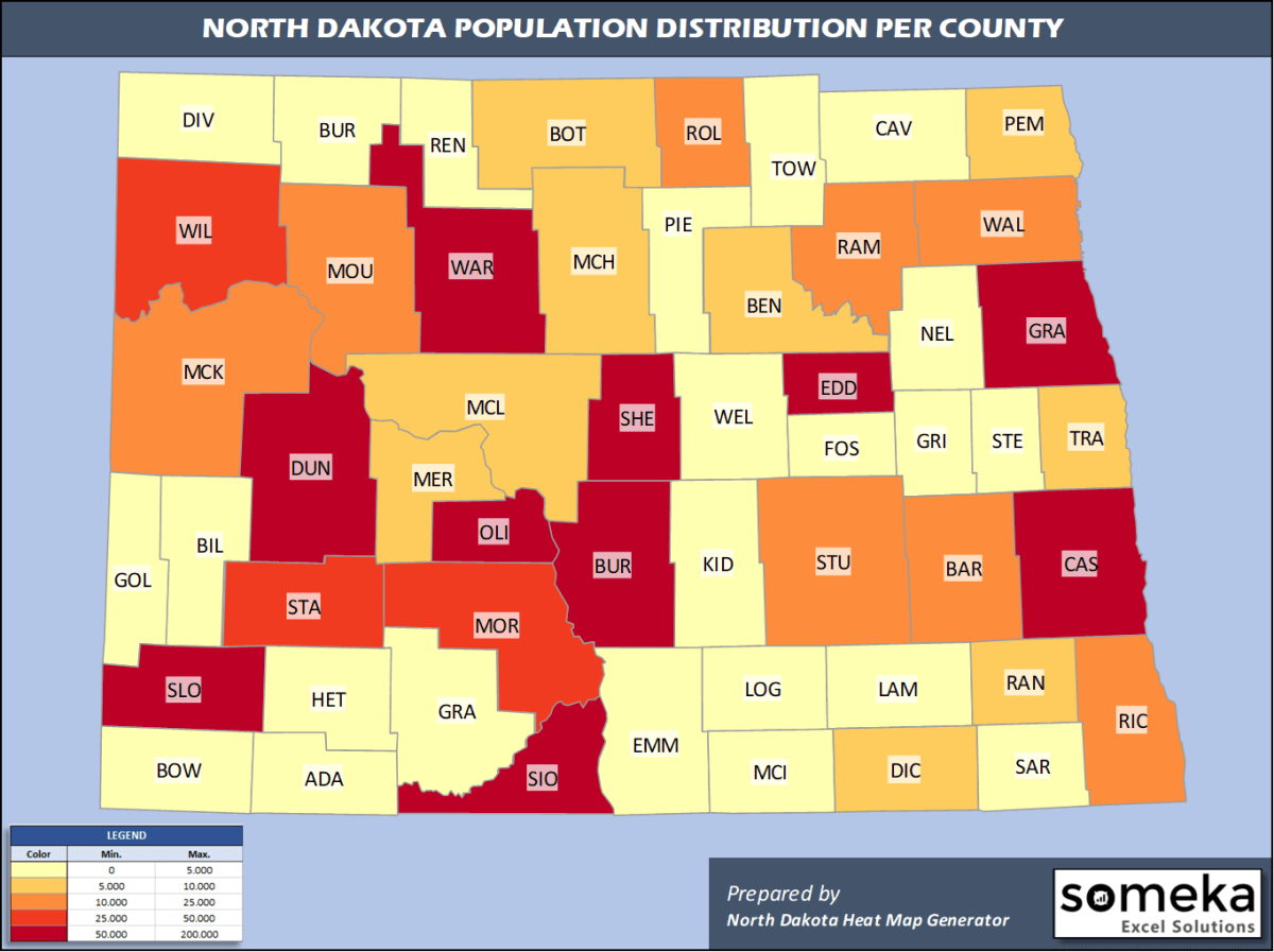
We have prepared this easily with North Dakota County Heat Map Generator for population info. But it can also be used for many different data types such as employment rate, average temperature, racial distribution and so on.
Below are 53 North Dakota counties ranked by population information. The data is from the US Census Bureau. You can copy and paste this list directly into your spreadsheet.
(Top 10 counties shown. To expand the list, simply click on the “show more” button)
| Rank | County | Population |
|---|---|---|
| 1 | Cass County | 181,923 |
| 2 | Burleigh County | 95,626 |
| 3 | Grand Forks County | 69,451 |
| 4 | Ward County | 67,641 |
| 5 | Williams County | 37,589 |
| 6 | Stark County | 31,489 |
| 7 | Morton County | 31,364 |
| 8 | Stutsman County | 20,704 |
| 9 | Richland County | 16,177 |
| 10 | McKenzie County | 15,024 |
| 11 | Rolette County | 14,176 |
| 12 | Ramsey County | 11,519 |
| 13 | Walsh County | 10,641 |
| 14 | Mountrail County | 10,545 |
| 15 | Barnes County | 10,415 |
| 16 | McLean County | 9,450 |
| 17 | Mercer County | 8,187 |
| 18 | Traill County | 8,036 |
| 19 | Benson County | 6,832 |
| 20 | Pembina County | 6,801 |
| 21 | Bottineau County | 6,282 |
| 22 | McHenry County | 5,745 |
| 23 | Ransom County | 5,218 |
| 24 | Dickey County | 4,872 |
| 25 | Dunn County | 4,424 |
| 26 | Sioux County | 4,230 |
| 27 | LaMoure County | 4,046 |
| 28 | Pierce County | 3,975 |
| 29 | Sargent County | 3,898 |
| 30 | Wells County | 3,834 |
| 31 | Cavalier County | 3,762 |
| 32 | Emmons County | 3,241 |
| 33 | Foster County | 3,210 |
| 34 | Bowman County | 3,024 |
| 35 | Nelson County | 2,879 |
| 36 | Hettinger County | 2,499 |
| 37 | McIntosh County | 2,497 |
| 38 | Kidder County | 2,480 |
| 39 | Renville County | 2,327 |
| 40 | Eddy County | 2,287 |
| 41 | Grant County | 2,274 |
| 42 | Divide County | 2,264 |
| 43 | Griggs County | 2,231 |
| 44 | Adams County | 2,216 |
| 45 | Towner County | 2,189 |
| 46 | Burke County | 2,115 |
| 47 | Oliver County | 1,959 |
| 48 | Steele County | 1,890 |
| 49 | Logan County | 1,850 |
| 50 | Golden Valley County | 1,761 |
| 51 | Sheridan County | 1,315 |
| 52 | Billings County | 928 |
| 53 | Slope County | 750 |
Out of the 53 counties in North Dakota, Cass County is the largest by population. Dare County is the largest by land area.
Slope County is the smallest North Dakota county by population. Eddy County is the smallest by size.
In terms of economics and average income level, Williams County is the richest North Dakota county.
Sioux County is the poorest North Dakota county.
We have prepared North Dakota county density map by population as a downloadable PDF.
You can download the PDF for free from the link below:

North Dakota County Density Map PDF
Check the video below to see how we use our North Dakota County Map Excel Template to visualize any data over North Dakota counties.
We have built the easiest North Dakota Heat Map Maker in the universe! It works fully in Excel:
Here is a list of useful links which we think can be helpful whether you work on data visualization or make research about North Dakota state and North Dakota counties.
Data Source for Population and many other US related data:
https://www.census.gov
Wikipedia Page for List of North Dakota Counties:
https://en.wikipedia.org/wiki/List_of_counties_in_North_Dakota
Official Website of the State of North Dakota:
https://www.nd.gov
Are you looking for North Dakota Zip Code map?:
North Dakota Zip Code Heat Map Generator in Excel

