
The US state Colorado (CO) is the 21st largest state by population and 8th biggest state by area. Colorado has 64 counties ranking it the 24th state with the most counties in USA. See below some basic information about the state:
| Country: | United States |
| State: | Colorado |
| Abbreviation: | CO |
| Capital: | Denver |
| Largest City: | Denver |
| Population: | 5,758,736 |
| Population rank in US: | 21st |
| Total Area [mi²]: | 104,094 |
| Total Area [km²]: | 269,837 |
| Area rank in US: | 8th |
| Number of Counties: | 64 |
If you want to show data distributon per geographical area, density maps (or heat maps) are a great way to achieve this. For example, here is a Colorado Population Density Map per County:
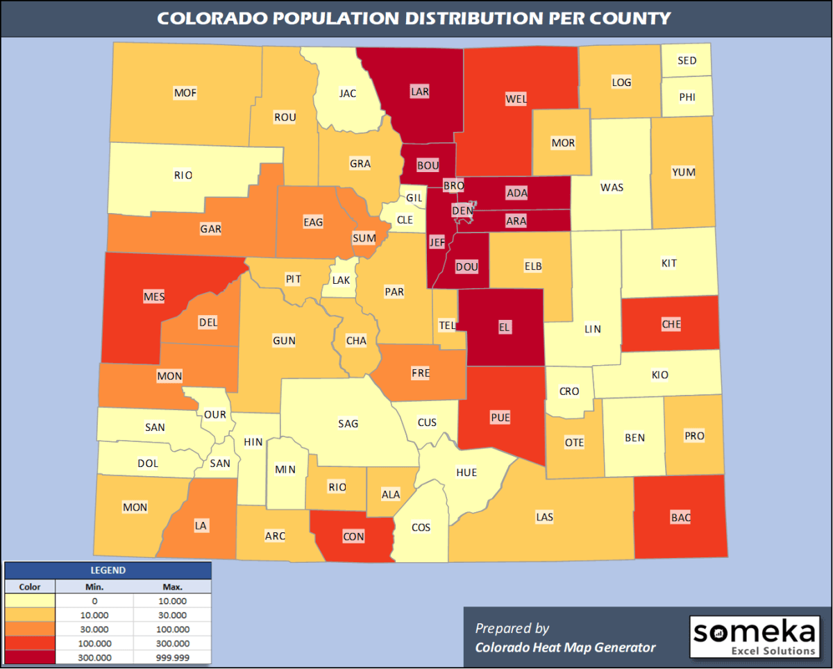
We have prepared this easily with Colorado County Heat Map Generator for population info. But it can also be used for many different data types such as employment rate, average temperature, racial distribution and so on.
Below are 64 Colorado counties ranked by population information. The data is from the US Census Bureau. You can copy and paste this list directly into your spreadsheet.
(Top 10 counties shown. To expand the list, simply click on the “show more” button)
| Rank | County | Population |
|---|---|---|
| 1 | Denver County | 727,211 |
| 2 | El Paso County | 720,403 |
| 3 | Arapahoe County | 656,590 |
| 4 | Jefferson County | 582,881 |
| 5 | Adams County | 517,421 |
| 6 | Larimer County | 356,899 |
| 7 | Douglas County | 351,154 |
| 8 | Boulder County | 326,196 |
| 9 | Weld County | 324,492 |
| 10 | Pueblo County | 168,424 |
| 11 | Mesa County | 154,210 |
| 12 | Broomfield County | 70,465 |
| 13 | Garfield County | 60,061 |
| 14 | La Plata County | 56,221 |
| 15 | Eagle County | 55,127 |
| 16 | Fremont County | 47,839 |
| 17 | Montrose County | 42,758 |
| 18 | Delta County | 31,162 |
| 19 | Summit County | 31,011 |
| 20 | Morgan County | 29,068 |
| 21 | Elbert County | 26,729 |
| 22 | Montezuma County | 26,183 |
| 23 | Routt County | 25,638 |
| 24 | Teller County | 25,388 |
| 25 | Logan County | 22,409 |
| 26 | Chaffee County | 20,356 |
| 27 | Park County | 18,845 |
| 28 | Otero County | 18,278 |
| 29 | Pitkin County | 17,767 |
| 30 | Gunnison County | 17,462 |
| 31 | Alamosa County | 16,233 |
| 32 | Grand County | 15,734 |
| 33 | Las Animas County | 14,506 |
| 34 | Archuleta County | 14,029 |
| 35 | Moffat County | 13,283 |
| 36 | Prowers County | 12,172 |
| 37 | Rio Grande County | 11,267 |
| 38 | Yuma County | 10,019 |
| 39 | Clear Creek County | 9,700 |
| 40 | Conejos County | 8,205 |
| 41 | San Miguel County | 8,179 |
| 42 | Lake County | 8,127 |
| 43 | Kit Carson County | 7,097 |
| 44 | Huerfano County | 6,897 |
| 45 | Saguache County | 6,824 |
| 46 | Rio Blanco County | 6,324 |
| 47 | Gilpin County | 6,243 |
| 48 | Crowley County | 6,061 |
| 49 | Lincoln County | 5,701 |
| 50 | Bent County | 5,577 |
| 51 | Custer County | 5,068 |
| 52 | Ouray County | 4,952 |
| 53 | Washington County | 4,908 |
| 54 | Phillips County | 4,265 |
| 55 | Costilla County | 3,887 |
| 56 | Baca County | 3,581 |
| 57 | Sedgwick County | 2,248 |
| 58 | Dolores County | 2,055 |
| 59 | Cheyenne County | 1,831 |
| 60 | Kiowa County | 1,406 |
| 61 | Jackson County | 1,392 |
| 62 | Hinsdale County | 820 |
| 63 | Mineral County | 769 |
| 64 | San Juan County | 728 |
Out of the 64 counties in Colorado, Denver County is the largest by population. Las Animas County is the largest by land area.
San Juan County is the smallest Colorado county by population. Broomfield County is the smallest by size.
In terms of economics and average income level, Douglas County is the richest Colorado county.
Otero County is the poorest Colorado county.
We have prepared Colorado county density map by population as a downloadable PDF.
You can download the PDF for free from the link below:

Colorado County Density Map PDF
Check the video below to see how we use our Colorado County Map Excel Template to visualize any data over Colorado counties.
We have built the easiest Colorado Heat Map Maker in the universe! It works fully in Excel:
Here is a list of useful links which we think can be helpful whether you work on data visualization or make research about Colorado state and Colorado counties.
Data Source for Population and many other US related data:
https://www.census.gov
Wikipedia Page for List of Colorado Counties:
https://en.wikipedia.org/wiki/List_of_counties_in_Colorado
Official Website of the State of Colorado:
https://www.colorado.gov
Are you looking for Colorado Zip Code map?:
Colorado Zip Code Heat Map Generator in Excel

