
The US state Arkansas (AR) is the 33rd largest state by population and 29th biggest state by area. Arkansas has 75 counties ranking it the 18th state with the most counties in USA. See below some basic information about the state:
| Country: | United States |
| State: | Arkansas |
| Abbreviation: | AR |
| Capital: | Little Rock |
| Largest City: | Little Rock |
| Population: | 3,017,804 |
| Population rank in US: | 33rd |
| Total Area [mi²]: | 53,179 |
| Total Area [km²]: | 137,732 |
| Area rank in US: | 29th |
| Number of Counties: | 75 |
If you want to show data distributon per geographical area, density maps (or heat maps) are a great way to achieve this. For example, here is a Arkansas Population Density Map per County:
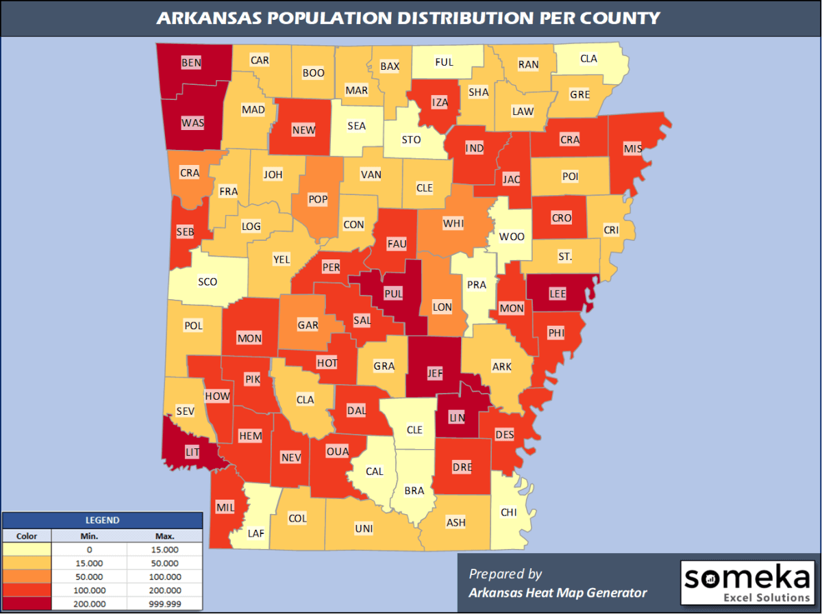
We have prepared this easily with Arkansas County Heat Map Generator for population info. But it can also be used for many different data types such as employment rate, average temperature, racial distribution and so on.
Below are 75 Arkansas counties ranked by population information. The data is from the US Census Bureau. You can copy and paste this list directly into your spreadsheet.
(Top 10 counties shown. To expand the list, simply click on the “show more” button)
| Rank | County | Population |
|---|---|---|
| 1 | Pulaski County | 391,911 |
| 2 | Benton County | 279,141 |
| 3 | Washington County | 239,187 |
| 4 | Sebastian County | 127,827 |
| 5 | Faulkner County | 126,007 |
| 6 | Saline County | 122,437 |
| 7 | Craighead County | 110,332 |
| 8 | Garland County | 99,386 |
| 9 | White County | 78,753 |
| 10 | Lonoke County | 73,309 |
| 11 | Jefferson County | 66,824 |
| 12 | Pope County | 64,072 |
| 13 | Crawford County | 63,257 |
| 14 | Crittenden County | 47,955 |
| 15 | Greene County | 45,325 |
| 16 | Miller County | 43,257 |
| 17 | Baxter County | 41,932 |
| 18 | Mississippi County | 40,651 |
| 19 | Union County | 38,682 |
| 20 | Independence County | 37,825 |
| 21 | Boone County | 37,432 |
| 22 | Hot Spring County | 33,771 |
| 23 | Carroll County | 28,380 |
| 24 | Johnson County | 26,578 |
| 25 | St. Francis County | 24,994 |
| 26 | Cleburne County | 24,919 |
| 27 | Poinsett County | 23,528 |
| 28 | Columbia County | 23,457 |
| 29 | Ouachita County | 23,382 |
| 30 | Clark County | 22,320 |
| 31 | Hempstead County | 21,532 |
| 32 | Logan County | 21,466 |
| 33 | Yell County | 21,341 |
| 34 | Conway County | 20,846 |
| 35 | Polk County | 19,964 |
| 36 | Ashley County | 19,657 |
| 37 | Grant County | 18,265 |
| 38 | Drew County | 18,219 |
| 39 | Randolph County | 17,958 |
| 40 | Phillips County | 17,782 |
| 41 | Franklin County | 17,715 |
| 42 | Arkansas County | 17,486 |
| 43 | Sharp County | 17,442 |
| 44 | Sevier County | 17,007 |
| 45 | Jackson County | 16,719 |
| 46 | Marion County | 16,694 |
| 47 | Madison County | 16,576 |
| 48 | Van Buren County | 16,545 |
| 49 | Cross County | 16,419 |
| 50 | Lawrence County | 16,406 |
| 51 | Clay County | 14,551 |
| 52 | Izard County | 13,629 |
| 53 | Howard County | 13,202 |
| 54 | Lincoln County | 13,024 |
| 55 | Stone County | 12,506 |
| 56 | Fulton County | 12,477 |
| 57 | Little River County | 12,259 |
| 58 | Desha County | 11,361 |
| 59 | Bradley County | 10,763 |
| 60 | Pike County | 10,718 |
| 61 | Perry County | 10,455 |
| 62 | Scott County | 10,281 |
| 63 | Chicot County | 10,118 |
| 64 | Montgomery County | 8,986 |
| 65 | Lee County | 8,857 |
| 66 | Nevada County | 8,252 |
| 67 | Prairie County | 8,062 |
| 68 | Cleveland County | 7,956 |
| 69 | Searcy County | 7,881 |
| 70 | Newton County | 7,753 |
| 71 | Dallas County | 7,009 |
| 72 | Monroe County | 6,701 |
| 73 | Lafayette County | 6,624 |
| 74 | Woodruff County | 6,320 |
| 75 | Calhoun County | 5,189 |
Out of the 75 counties in Arkansas, Pulaski County is the largest by population. Union County is the largest by land area.
Calhoun County is the smallest Arkansas county by population. Lafayette County is the smallest by size.
In terms of economics and average income level, Pulaski County is the richest Arkansas county.
Phillips County is the poorest Arkansas county.
We have prepared Arkansas county density map by population as a downloadable PDF.
You can download the PDF for free from the link below:

Arkansas County Density Map PDF
Check the video below to see how we use our Arkansas County Map Excel Template to visualize any data over Arkansas counties.
We have built the easiest Arkansas Heat Map Maker in the universe! It works fully in Excel:
Here is a list of useful links which we think can be helpful whether you work on data visualization or make research about Arkansas state and Arkansas counties.
Data Source for Population and many other US related data:
https://www.census.gov
Wikipedia Page for List of Arkansas Counties:
https://en.wikipedia.org/wiki/List_of_counties_in_Arkansas
Official Website of the State of Arkansas:
https://portal.arkansas.gov/
Are you looking for Arkansas Zip Code map?:
Arkansas Zip Code Heat Map Generator in Excel

